


Mayview Voting District, Garfield County, Washington
About
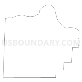
Outline
Summary
| Unique Area Identifier | 684278 |
| Name | Mayview Voting District |
| County | Garfield County |
| State | Washington |
| Area (square miles) | 73.84 |
| Land Area (square miles) | 71.54 |
| Water Area (square miles) | 2.30 |
| % of Land Area | 96.89 |
| % of Water Area | 3.11 |
| Latitude of the Internal Point | 46.61560970 |
| Longtitude of the Internal Point | -117.53087680 |
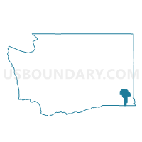
Maps


Graphs
Select a template below for downloading or customizing gragh for Mayview Voting District, Garfield County, Washington


Neighbors
Neighoring Voting District (by Name) Neighboring Voting District on the Map
- Colton Voting District, Whitman County, WA
- Pataha Voting District, Garfield County, WA
- Ping Voting District, Garfield County, WA
- Pleasant Voting District, Garfield County, WA
- Scoggin Voting District, Garfield County, WA
- South Pullman Voting District, Whitman County, WA
- Wilcox Voting District, Whitman County, WA
Top 10 Neighboring County Subdivision (by Population) Neighboring County Subdivision on the Map
- Uniontown CCD, Whitman County, WA (1,194)
- LaCrosse CCD, Whitman County, WA (921)
- Snake River CCD, Garfield County, WA (391)
Top 10 Neighboring Unified School District (by Population) Neighboring Unified School District on the Map
- Pullman School District, WA (31,922)
- Colfax School District, WA (3,985)
- Pomeroy School District, WA (2,191)
- Colton School District, WA (1,106)